Santa Barbara Channel
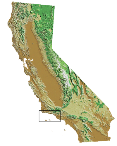
The Santa Barbara Channel (SBC) region extends from Point Conception in Santa Barbara County south to Point Dume in Ventura County and includes the four Northern Channel Islands. The historic importance of fisheries resources in this area is evident from the activities of the Chumash Indians. Archaeologists have found large 'middens' - remnant piles of a great variety of shells and fish bones - illustrating the significance of seafood to the diet of native peoples long before European settlement. Today, the region provides seafood worldwide, from a diversity of both finfish and shellfish fisheries.
- Fishing communities
This region encompasses two counties with four primary port-based fishing communities (listed north to south):
Santa Barbara County Ventura County Santa Barbara Ventura Channel Islands (Oxnard) Harbor Port Hueneme - Types of commercial fisheries
The region supports a variety of fisheries, with squid, lobster, and sea urchin among the most active. Landings vary among the four harbors, with Port Hueneme and Ventura supporting the larger, coastal pelagic species (market squid in particular) purse seine operations, and Santa Barbara and Channel Islands (Oxnard) harbors prmarily serving the smaller dive, trap and trawl operations. The mix of fisheries and level of activity in each port and overall varies as a function of changes in species distribution and availability, market demand, regulations, physical infrastructure, buyers and other factors.
In 2013, commercial fishermen landed more than 111 million pounds (50,350 metric tons) of seafood in this region with an ex-vessel value (amount paid to fishermen) of nearly $50.5 million. The top fisheries (species-gear combinations, in alphabetical order) in terms of pounds landed and/or ex-vessel value included:
See our regional seafood posters and the commercial fishery landings data (links below) to learn more about the fisheries of this region.
Ex-Vessel Value (≥ $1.4 million each) Pound Landed (≥ 1.5 million pounds each) Market squid seine Coastal pelagic finfish (anchovy, sardine) seine Red sea urchin dive Market squid seine Rock crab trap Red sea urchin dive Spiny lobster trap Rock crab trap Spot prawn trap, trawl - Fisheries Seasonality
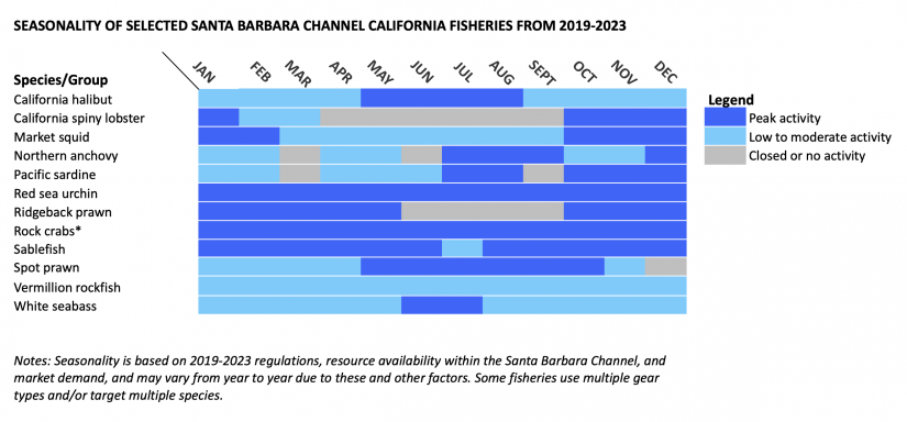
The chart below shows the times when the major commercial fisheries of the Santa Barbara Channel region are most active. Other smaller fisheries, while also important, are not shown here. This chart combines all gear types that target the indicated species. Note that fishing activity does not necessarily start at the beginning or stop at the end of a month, and that the timing and types of fisheries may vary from year to year. (See state and federal commercial fishing regulations for current and specific dates.)
Seasonality of selected Santa Barbara Channel California fisheries FROM 2019-2023
The local ocean environment
The Santa Barbara Channel (SBC) region is the northern portion of the Southern California Bight, an area that extends from Point Conception to Baja California in Mexico. A great diversity of fisheries occur in the SBC region due to several key features:
- Oceanographic transition zone
- Strong upwelling zone
- Northern Channel Islands
- Port Hueneme Submarine Canyon
The SBC is a transition zone where the cold waters north of Point Conception mix with the warm waters of Southern California, resulting in a complex system of oceanographic currents and a great diversity of northern and southern ocean species. Upwelling occurs off Point Conception (usually from March through September), providing cold, nutrient-rich waters that move eastward throughout the channel. The region also includes the four Northern Channel Islands – San Miguel, Santa Rosa, Santa Cruz and Anacapa – and associated rocky reefs and kelp forests that are located 12-28 statute miles (19-45 km) off the coast. These islands provide additional habitat for marine life and some protection from southerly storms.
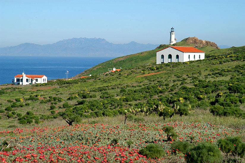
Looking over wildflowers and cactus to historic buildings and the Anacapa Island Lighthouse. Channel Islands National Marine Sanctuary, California. February 1, 2007. Photographer: Robert Schwemmer, CINMS, NOAA - The Management Context
The region's commercial fisheries are managed by the state through the California Legislature, the Fish and Game Commission and the Department of Fish and Wildlife (CDFW); by the federal government through the Pacific Fishery Management Council (PFMC) and National Marine Fisheries Service (NMFS); or by both (see Management Context for more information). The following table shows which government entity (or entities) has management authority and the management measures used for some of the region’s most active fisheries.
Fishery Management Authority Management Measures State Federal Limited entry Quotas Time/area closures Species size/sex rules Gear restrictions Blackcod (sablefish) hook-and-line, trap, trawl ✓ ✓ ✓ ✓ ✓ ✓ ✓ Coastal pelagic finfish seine ✓ ✓ ✓ ✓ ✓ ✓ Market squid seine ✓ ✓ ✓ ✓ ✓ Red sea urchin dive ✓ ✓ ✓ ✓ ✓ Rock crab trap ✓ ✓ ✓ ✓ Sea cucumber dive, trawl ✓ ✓ ✓ ✓ Spiny lobster trap ✓ ✓ ✓ ✓ ✓ Spot prawn trap ✓ ✓ ✓ ✓ Note: Management authority and/or measures may vary for a given fishery depending on species and/or gear type
- Information Sources
- California Marine Life Protection Act Initiative (CA MLPAI). 2009. CA MLPAI Regional Profile of the South Coast Study Region (Point Conception to the California-Mexico Border), June 25, 193 pp.
- Hackett, S. 2002. An Economic Overview of the California Wetfish Industry Complex. In California's "Wetfish" Industry: It's Importance Past, Present and Future, edited by D. Pleschner-Steele, Santa Barbara, CA: California Seafood Council, 65 pp.
- Leet, W.S., Dewees, C.M., Klingbeil, R. and E.J. Larson. 2001. California's Living Marine Resources: A Status Report. 4th ed. Sacramento, CA: CDFG, 562 pp.
- Pomeroy, C., M. Hunter and M. Los Huertos. 2002. Socio-Economic Profile of the California Wetfish Industry. In California's "Wetfish" Industry: It's Importance Past, Present and Future, edited by D. Pleschner-Steele, Santa Barbara, CA: California Seafood Council, 42 pp.
- San Diego History Center. 2012. TUNA! Celebrating San Diego's Famous Fishing Industry. Museum exhibit, Apr 21-Dec 31.
- CDFW Commercial Landings Information
- NMFS Commercial Fisheries Statistics
- Pacific States Marine Fisheries Commission (PSMFC) Pacific Fisheries Information Network (PacFIN)
- Southern California Ocean Observing System (SCCOOS)