Site Assessment Plans
- What are Site Assessment Plans?
A site assessment plan (SAP) is proposed by a Wind Developer to better understand the lease area and to determine where it might be appropriate to locate key infrastructure. The SAP is submitted to the Bureau of Ocean Energy Management (BOEM) within 12 months of receiving a lease. BOEM reviews the SAP for completeness and sufficiency. For any activity that may deploy new technology or take up a large part of the lease, BOEM may require additional verification. BOEM reviews the SAP within 90 days. If the SAP is adequate, developers will proceed with activities which will include installing metocean (meteorological/oceanographic) buoys to measure the site’s conditions and to assess the quality of the wind resources. On the basis of this information, commercial developers will decide whether they will proceed with construction.
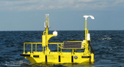
Example of a potential metocean buoy.
- When will the Site Assessments begin?
A site assessment plan (SAP) is proposed by a Wind Developer to better understand the lease area and to determine where it might be appropriate to locate key infrastructure. The SAP is submitted to the Bureau of Ocean Energy Management (BOEM) within 12 months of receiving a lease. BOEM reviews the SAP for completeness and sufficiency. For any activity that may deploy new technology or take up a large part of the lease, BOEM may require additional verification. BOEM reviews the SAP within 90 days. If the SAP is adequate, developers will proceed with activities which will include installing metocean (meteorological/oceanographic) buoys to measure the site’s conditions and to assess the quality of the wind resources. On the basis of this information, commercial developers will decide whether they will proceed with construction.
- What types of activities will be part of the Site Assessments?
The assessments will include the installation of buoys to collect wind data. Survey vessels will also conduct high-resolution geophysical surveys to better understand the nature of the seabed floor. Geotechnical sampling will be conducted to understand where it might be appropriate to install infrastructure. Biological assessments will also be conducted including using grab samples, aerial surveys, acoustic monitoring, environmental DNA, and underwater imagery.
- What environmental issues might be associated with Site Assessments?
Sources of noise during site assessments may include high-resolution geophysical surveys (e.g. sub-bottom profilers), geotechnical sampling of the sea floor (cores and cone penetration tests), vessel engines, and diesel engines for metocean buoys where solar/wind are not available.
Vessels will be used for surveys and there is a very small possibility of a vessel strike of sea life as with all ocean going vessels. Best practices are required. Every vessel must have a trained crew member or protected species observer on board to ensure that vessels watch speed limits and avoid marine mammals. This observer is also responsible for ensuring that protected species are not visible in the vicinity during surveying efforts that generate noise. For more information on avoiding marine mammals and minimizing environmental impacts associated with site assessment activities, please see the expected best management practices from the Environmental Assessment that were originally developed for oil and gas operations but will be applied to offshore wind development activities. [1]
[1] Appendix D, Typical Best Management Practices for Operations on the Pacific Outer Continental Shelf, https://www.boem.gov/sites/default/files/documents/renewable-energy/state-activities/2022-App-D-Typical-BMPs.pdf