Rocky intertidal habitats occur where the land meets the sea: they’re where you can kneel next to the small pools of water left behind at low tide and marvel at the brilliantly colored sea stars and otherworldly urchins. Filled with species uniquely adapted to live amidst crashing waves, as well as alternating periods of total submersion and full sun, they are some of the most biodiverse places in the world.
They are also a critical part of California’s Marine Protected Area (MPA) system. Peter Raimondi, Professor in the Ecology and Evolutionary Biology Department at U.C. Santa Cruz, and his team have been studying rocky intertidal habitats for decades, even before the establishment of MPAs. Their detailed data on the biodiversity present in these habitats was used to help design the size and location of the new MPAs. Now, with funding from the Ocean Protection Council, administered by California Sea Grant in partnership with California Department of Fish and Wildlife, they are continuing to monitor their long-established research sites to understand whether the MPAs are effective at protecting this unique environment. The data will also be crucial for assessing the ecological damage wrought by oil spills such as the October 2021 spill occurring off the southern California coast.
Raimondi’s team conducts two different types of surveys, both of which involve standardized protocols that allow for seamless integration across research projects, maximizing the usefulness of the data.
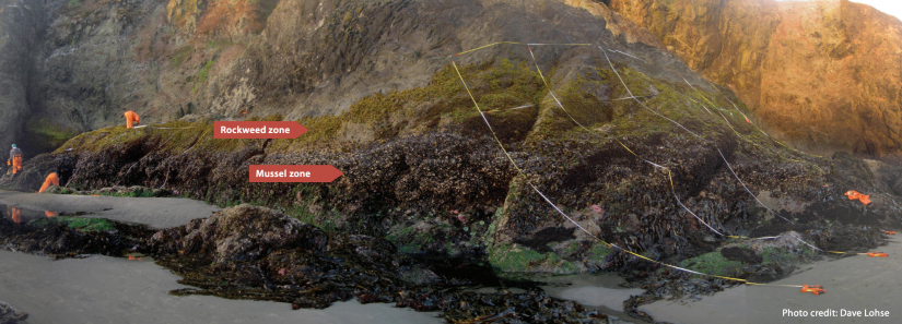
First, long-term surveys are conducted each year and involve re-visiting established locations. At each site, researchers break down the habitat into distinct groups that vary according to distance from the low tide line: these are visible as bands of dominant species such as mussel beds or seagrass. The surveys focus on keystone and foundation species, with the idea that changes in these species will signal, or directly lead to, changes across the community.
A second, more detailed biodiversity survey occurs every 3-4 years and encapsulates the many thousands of species found in the state’s intertidal habitats. Each site is overlaid with a grid of points that are mapped in three dimensions, including latitude, longitude and tidal elevation. This produces a layered image of everything found at that specific point in time.
These two survey datasets supplement each other and enable researchers to understand both the size and the scope of changes, from the geographic extent of a growing mussel bed to the percentage change in the population.
In addition to the surveys, the project includes the development of web-based tools for sharing the data with other researchers, resource managers and the public. Already up and running, the website includes an interactive GIS map that gives users a visual summary of the data from each of the survey sites. It also includes a detailed map and explanation of how the biodiversity surveys have uncovered three distinct groups of intertidal communities in the Channel Islands, believed to be the result of variations in ocean temperature. With this level of understanding of how ecological communities respond to changes in water temperature, researchers and resource managers can better predict how intertidal zones might respond to the climate crisis.
All of this data is helping to paint a picture of how effective California’s new MPAs are at protecting intertidal communities. This is a big task, because protecting marine areas is a relatively recent experiment, and scientists are still assessing whether the protected areas will have the same benefits in marine environments that we see on land. One of the most notable changes Raimondi has seen is the sense of stewardship that occurs when an area is protected.
“When you say ‘this is an area we’re protecting,’ not just a species, which is amorphous in space, I think that’s more substantive to most people,” he says. This is demonstrated in the results showing changes in harvested species like abalone, which change not only in numbers when harvesting is restricted, but also in size structure.
One of the project’s most significant findings is that the sites inside of MPAs are showing greater resiliency to disturbance, including to marine heatwaves. This is what scientists hoped for when designing the MPAs, conceptualizing them as an interconnected network that would ideally be productive enough to buffer not only each protected area, but also the surrounding region and even other MPAs.
“That was something that we really hoped would ensue, but it was really not something that we expected... This could be a big deal,” says Raimondi.
The hope is that this increased connectivity and associated resiliency will help rocky intertidal zones bounce back from environmental crises like oil spills.
Researchers use the survey data to characterize the loss that occurs when disaster strikes. “If we have a previous sample, then if the oil does come ashore, then we'll have what was there, what was hit, and what was lost. And that all plays into the Natural Resource Damage Assessment, which is a way to kind of quantify what’s called ‘ecological injury,’ that can then be monetized. And then the estimated value lost of the ecology can be passed on to the responsible party,” says Raimondi. At the time of this interview, his team was en route from Santa Cruz to Huntington Beach to respond to the oil spill that was measured at 13 miles long on October 4, 2021.
In the face of these environmental challenges, the Marine Protected Area Monitoring Program is a good example of the strength of collaborative efforts when implementing large-scale conservation initiatives. People have come together across state and federal agencies, universities, nonprofits, and other groups, to make California’s MPA network a reality.
“This really could have failed so many times, because it’s complicated. The politics, the number of players, the amount of controversy, it could have just failed. But there’s been really good people who have been dedicated to this over time and because of them, it’s working,” says Raimondi.
About California Sea Grant
NOAA’s California Sea Grant College Program funds marine research, education and outreach throughout California. Headquartered at Scripps Institution of Oceanography at the University of California San Diego, California Sea Grant is one of 34 Sea Grant programs in the National Oceanic and Atmospheric Administration (NOAA), U.S. Department of Commerce.