N/A


If you visit beaches in Santa Barbara or Ventura, you might have come across a small group of people with measuring sticks and notepads, carefully surveying the beach. These surveyors are volunteers with California Sea Grant working as citizen scientists to learn more about how California beaches are changing to help with beach management and conservation. Here’s what they say:
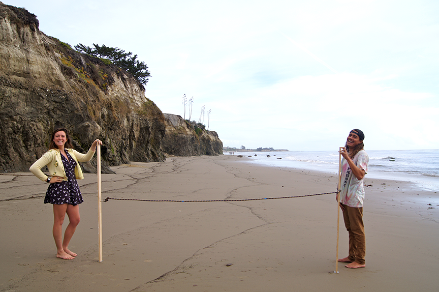
What are you surveying? We are measuring the beach profile, the shape of the beach, including how steep and wide it is.
Why measure the beach profile? Beaches are dynamic, changing shape on daily, seasonal, annual and longer timescales. We are monitoring how sandy beaches change over time to help track accumulation and loss of sand along our coastline.
Why track the sand? Sandy beaches are a valuable natural resource for both wildlife and humans. These dynamic ecosystems provide food and habitat for many types of wildlife, attract tourists, provide space for recreation and protect coastal development from wave damage. Beach profile monitoring can help with management and conservation efforts that support these ecosystems.
Where does the sand come from and go to? The mountains are the primary source of sand to the coastline. Rainfall carries sediment down to the coast and then waves and long-shore currents transport the refined sediment as sand along the coastline. Ultimately, sand is deposited in deep-water ocean trenches, or submarine canyons.
Why monitor now? It is projected that two thirds of California beaches will be lost by 2100 with severe loss occurring in the next 35 years. There is a need to determine the locations and rates at which this will occur and identify wide beaches that provide opportunities for climate adaptation.
Beach monitoring will help track changes to sandy beaches, but a strong volunteer force is needed. While government scientists collect excellent, high tech data on shoreline change, they only have capacity to survey twice per year. Volunteers are able to collect data frequently, and while it is low-tech, it is essential for filling data gaps. Local volunteers also have flexibility to monitor before and after storm events or other natural disasters – something that is difficult to do rapidly without a local team.
For example, CoAST SB volunteers were some of the earliest, if not the first, people to collect scientific data about the dramatic changes to local beaches that resulted from the 2018 Montecito debris flow. These data will be useful for predicting future impacts and recovery from natural events.
How will the data you’re collecting be used? The data we are collecting will be used by agencies like the USGS, who are working to better understand current and future evolution of our coastline. The data can be incorporated in the USGS Coastal Storm Modeling System (CoSMoS) that projects future shoreline change and coastal hazards. The data will improve the ability to predict potential impacts on structures (e.g., houses, parking lots, piers, railroads, highways) and the food and space that beaches provide for wildlife and human activities.
So what’s happening with our beaches? A lot! Many beaches are narrowing as a result of coastal modifications (armoring), such as seawalls and rock revetments, which prevent sand from being deposited landward and accelerate the loss of sand off the beach.
Further, in some areas dams limit the natural flow and supply of sediment to beaches, further exacerbating the issue. This is particularly problematic in California because many of the beaches are already naturally narrow, bluff-backed beaches. As sea levels rise we will loose the upper, dry sand section of these beaches, leaving no room for people to play, marine mammals to haul out or birds to nest.
Volunteer Information
Who can volunteer? Dedicated individuals are welcome to volunteer after completing training if they are at least 12 years old (children under 18 must be with an adult). Volunteers need a reliable means of getting to and from the beach with minimal gear and should be prepared to navigate rocky terrain at times. Teams of 2-3 individuals are required for monitoring, thus you are encouraged to set-up your own team with friends, family members, and co-workers.
When do you survey? We survey beaches in Santa Barbara and Ventura Counties once per month at low tide when the horizon is visible (no fog). Volunteer teams choose when they survey from a list of appropriate dates and times based on the local tides. If the day turns out to be foggy, they choose another date.
What supplies will I need? After an in-field training, volunteers are given a volunteer manual, measuring sticks, compass and data sheets. Volunteers need to bring a camera or phone to take photos and a watch or phone to record the time.
What if I miss a survey? Fortunately, there are many survey dates and times to choose from each month, but if you are unable to survey that is okay. Factors such as fog, access, or other commitments may inhibit the ability to survey. Someone else may be able to conduct the survey for you and, if not, there is always the next round of low tides.
How can I get started? Email Aaron (aaronhoward@ucsb.edu) to learn more about the program and we can usually set up a volunteer training within a week or two.
Written by Aaron Howard and Monique Myers

Related News
Dec 18, 2024