PROJECT HIGHLIGHT
This project developed a smartphone app that uses machine learning to detect rip currents in real-time, helping beachgoers identify dangerous ocean conditions and improving public safety at coastal locations across the U.S.
PROJECT SUMMARY
Rip currents pose a significant threat to ocean swimmers, causing an estimated 100 drowning deaths across the U.S. every year. While seasoned surfers recognize the telltale signs of these ocean phenomena and can use them to their advantage, less experienced swimmers often find themselves caught in dangerous situations. This safety gap highlighted the need for improved public awareness and real-time detection capabilities.
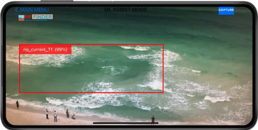
Armed with $150,000 in funding from the U.S. Coastal Research Program and the National Sea Grant Office, California Sea Grant partnered with NOAA senior scientist Greg Dusek and University of California, Santa Cruz computer science professor Alex Pang to address this challenge. The team successfully developed the RipFinder mobile app, which processes smartphone video through lightweight machine learning models to detect potential rip currents. The app focuses on identifying two common types: bathymetry-controlled rips and transient rips characterized by sediment discoloration.
The project addressed three main goals of reducing drowning deaths, educating the public about rip currents and engaging communities in improving rip current forecasting. Beta versions were deployed on both Android and iOS platforms and tested at locations including Santa Cruz, Solana Beach and La Jolla in California, as well as Volusia County in Florida. Local lifeguards participated in testing, and the app shares location information about detected rips with lifeguards, the WebCOOS (Webcams for Coastal Observations and Operational Support) network and NOAA to help continuously improve existing rip current forecast models. The project also contributed to scientific knowledge through peer-reviewed publications and helped establish new approaches for citizen science applications using machine learning.
 Ashleigh Palinkas