Transforming sea level rise into an opportunity
In North California, the sea rises faster than anywhere else in the state. But this also creates chances to work together and rekindle ecological knowledge systems, argues a recent paper.
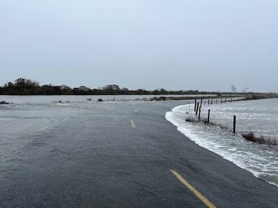
When Jason Patton bikes from his home in Manila, California, to the nearby town of Arcata, he rides along a peninsula at the edge of Humboldt Bay. His travels lead past levees that were built in the late 1880s to protect this narrow slip of land from the sea. But lately, their protection has started to feel precarious.
Patton says that in the past half-decade, the water has begun to run over levees at times. This tends to happen if storms arrive during king tides, when the gravitational forces of the moon and the sun have already pushed the water higher than usual. Patton knows that, due to climate change, the water could get higher still. “If and when sea level rise overtops these levees, I might not have access to my home anymore,” he says.
As an engineering geologist at the California Geological Survey, Patton knows only too well that the area around Humboldt Bay is experiencing the fastest relative sea level rise in California, if not the entire West Coast. It makes for a dicey situation, but one that also brings an opportunity for transformation, argues Patton, alongside 25 co-authors, in a recent paper in the Humboldt Journal of Social Relations.
Transformative sea level solutions
Sea level rise “presents people in our region with an opportunity to work together and envision a more just and resilient future,” write the authors, who came together from a wide swath of academia, Indigenous Tribes and community as well as government organizations. All authors are members of the interdisciplinary Sea Level Rise Institute at Cal Poly Humboldt. The SLRI formed in 2018 as a multidisciplinary initiative to incubate new “equitable, resilient and transformative” sea level rise solutions. Sea level rise “can only begin to be understood and addressed if different disciplines and types of knowledge are brought together,” the authors write.
The paper highlights five areas of expertise in particular: Indigenous knowledges, geosciences, marine and coastal science, engineering and social science. Taking inspiration from the seminal book “Braiding Sweetgrass” by Potawatomi Nation citizen and biologist Robin Wall Kimmerer, the authors state: “We can envision these different approaches or strands winding together and, in the winding, shaping and influencing one another until neither the individual disciplines nor the overall approach remain the same.”
Complex problems
The scale of the problem is made clear at the abandoned lumber mills that dot the Northern Californian coast, where the soil is often contaminated with wood-preserving toxins. The mills sit inside the levees, but the ground beneath them is sinking — as is much of the land around Humboldt Bay. The region lies atop two convergent tectonic plates, that is with one plate sliding beneath the other. As the lower plate descends, it’s pulling the upper plate with it. “Southern Humboldt Bay is going down at a rate of about 4.5 millimeters a year and the sea level is rising 1.5 millimeters per year, which means that the sea level is actually rising five to six millimeters per year,” says Patton. By 2060, the sea level of Humboldt Bay is expected to be as much as three feet higher than today.
Engineering higher dikes might seem like an obvious fix — but this won’t solve the problem. As the sea rises, the groundwater in the inland soils get pushed upward, too. This can cause areas behind the levees to flood from below and wash toxins from the contaminated mill soil into supplies of drinking water.
Braiding different strands of knowledge together
Challenges like this are “going to take a lot of smart people to figure out,” says SLRI member Jennifer Kalt, the director of the non-profit Humboldt Baykeeper and a co-author of the paper. Engineers may focus on 'hard' structures, like sea channels and sea walls, while marine and coastal scientists focus on 'soft' solutions like natural shorelines that buffer waves and restoration of contaminated coasts. Geologists can model where land movements create particularly high risk. Social scientists will work with landowners and communities to decide where to fight sea level rise and where to retreat. Indigenous tribes who have held stewardship of the land around Humboldt Bay since time immemorial can contribute centuries worth of knowledge of the coast and its wetlands.
“Our areas of expertise overlap. And if they don’t, then maybe they should,” says Kalt. “Sometimes when you're in your little silo, you don't really know about other perspectives.”
California’s North Coast — roughly defined as the coastal areas in Mendocino, Humboldt and Del Norte counties — faces many sea level rise challenges that will require such coming together. The area is more remote and less developed than urbanized Southern California and the Bay Area. Poverty rates hover around 20% in many places. Seventy-seven miles of Humboldt Bay’s shoreline consist of man-made earthen dikes that were built in the 1800s. Behind them, farmland used for crops and livestock are increasingly threatened by inundation, as is Highway 101, which connects California to Oregon and Washington. Sea level rise also endangers more than four dozen Indigenous cultural sites, a storage facility for spent nuclear fuel from a decommissioned Pacific Gas & Electric (PG&E) nuclear power plant and numerous wetlands that are important for migratory birds.
“They already live with that”
Some of the more disadvantaged communities are already feeling the effects of the rising ocean. In the former fishing village King Salmon, around 100 miles south of the Oregon border, streets and yards flood regularly now during king tides. “You look at the tide schedule and know when it’s coming,” says Laurie
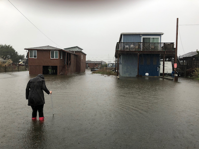
Richmond, a social scientist in Cal Poly Humboldt Department of Environmental Science & Management (and an extension agent with California Sea Grant), who co-chairs the SLRI. “People put their cars up on blocks and their possessions in the garage on pallets. Roads are closed during certain times of the year. They already live with that.”
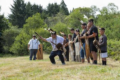
Recently, the SLRI partnered with the Wiyot Tribe to secure a $1.2 million grant from the state Ocean Protection Council (OPC) that allowed the tribe to purchase 46 acres of their ancestral land on a site called Mouralherwaqh from a private landowner. It was the first time the state of California has funded a tribal purchase as a part of addressing climate change. The parcel, one of the last undeveloped coastal properties on the historic fringe of Wigi (the Wiyot name for Humboldt Bay) contains freshwater wetlands. The tribe plans to implement ecological and cultural restoration. “A lot of the Western governments are a bit stuck on how to move forward on sea level rise,” says Richmond. “The tribes are leading on innovative approaches and it’s been some of the best things to be a part of.”
Traditional tribal customs of subsistence living helped buffer against the sea. As the Wiyots harvested clams and shellfish over thousands of years, a shell midden arose in the middle of Humboldt Bay. The arrival of white settlers and the subsequent development of a system of dikes put a stop to the practice and cut off coastal wetlands from the bay. “Almost 90% of the salt marsh and estuarine habitat was lost. It’s these areas that are now the most vulnerable to flooding,” says Adam Canter, natural resource director of the Wiyot Tribe and the second co-chair of the SLRI. Had the Wiyot been able to keep up their subsistence way of life, “those sites would be feet higher today,” says Canter.
Rekindling environmental knowledge systems
On the newly acquired Wiyot ancestral land – called Mouralherwaqh (pronounced "more-RAH-share-wahg") – the tribe will protect the large sedge of the freshwater wetlands and the surrounding Sitka spruce forest, where egrets and herons nest. “We will allow these habitats to migrate inland with the sea level,” says Canter. Elsewhere, too, there are efforts underway to restore the saltmarshes around the Bay, in hopes that they might buffer Highway 101 against the encroach of the ocean.
“A big point we make in the paper is that we can use this moment in time to rekindle relationships with the environment and ecological knowledge systems,” says Canter.
As the only major academic institution in the region, Cal Poly Humboldt is making such community and Indigenous-centered engineering one of its focal points. The university has launched a master’s degree in engineering and community practice that draws on Native/Indigenous knowledges and combines community-informed best practices with engineering to address environmental issues.
“Sea level rise comes with some scariness but it also does truly create an opportunity, says Alexandra Toyofuku, a recent Cal Poly Humboldt graduate who helped co-author the paper as a student. “A cool takeaway is how much is possible if the different fields come together.”
Or, as he and his co-authors put it in the paper: “Braided or woven materials are much stronger than individual strands.”