Natural Bridges. Photo: Erin Malsbury
California researchers spend hours crouched over rocky intertidal zones across the state, piecing together how best to protect marine life.
When 11 million gallons of crude oil spewed from the Exxon Valdez oil tanker into the frigid waters of Prince William Sound, Alaska in 1989, it seeped into tide pools and wreaked havoc on ecosystems along the coast. But scientists had few records of what the habitats were like before the spill, so they had no way of knowing the full extent of the damage. As researchers watched organisms in the rocky intertidal zone die, they devised a plan to inventory species across the West Coast and learn more about the ecosystem.
The intertidal zone is the area between high and low tides. The rocky intertidal—found on specific types of rocky coastline—exists as a tiny sliver along the coast. Researchers estimate that California has between five and fifteen square miles of rocky intertidal habitat in the entire state. Organisms that live there experience extreme shifts in conditions over the course of a single day—from baking under the sun, to pummeled with crashing waves, to completely submerged. Despite its harsh nature, the rocky intertidal zone serves as a home to unique and diverse communities of marine life including sea stars, anemones, seaweeds, barnacles, and abalone.
In response to the Exxon Valdez oil spill, the federal government created a program that ultimately led to MARINe—the Multi Agency Rocky Intertidal Network—in 1992 to monitor these habitats along the West Coast. The surveys began in the Santa Barbara Channel and grew to encompass over 150 sites stretching from southern Alaska to central Baja California in Mexico.
When California created a network of marine protected areas in 2012, and established a long-term monitoring program, it made sense to include some of the rocky intertidal sites that MARINe already monitored. Marine scientists across California are studying the impacts of marine protected areas on different types of ecosystems through seven large-scale monitoring projects funded by the California Ocean Protection Council and California Department of Fish and Wildlife through California Sea Grant. The range and consistency of MARINe monitoring data makes the rocky intertidal project unique.
“The MPA work has been folded into it, and the protocols are identical to what we’ve been doing in the past,” says UC Santa Cruz Marine Ecologist Peter Raimondi, who oversees the MARINe monitoring and the rocky intertidal component of the state’s long term monitoring. “We have a very long time series that we can draw upon for the assessment of the MPAs now.”
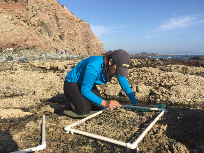
How do researchers monitor rocky intertidal sites?
Since the 1990s, teams of researchers from universities and institutions up and down the West Coast have visited permanent plots at each MARINe site once a year. During low tide, they meticulously record data about the diversity and abundance of a wide variety of organisms across the intertidal zone. They photograph the plots and upload information into a database.
Every few years, a specialized subset of the monitoring teams also conducts biodiversity surveys outside the permanent plots. In these surveys, scientists run transects from the top of the intertidal zone to the edge of the habitat. They examine 100 intervals along the line and record the three closest species to each point. CSU Fullerton Ecologist Jennifer Burnaford calls these types of surveys intense but rewarding. “50-meter lines and your points are 40 centimeters apart—you don’t get up and move 40 centimeters,” she says. “You crawl up and down the intertidal zone.” Burnaford also carries a step stool for tough-to-reach areas. “You definitely go through some bizarre yoga contortions,” she laughs. “You can’t just look down and say, ‘eh… I think it’s this.’ You literally have to get eyeball up.” But the diversity of the ecosystem makes the challenge worth it. She frequently sees organisms she either hasn’t seen before or hasn’t seen in several years.
With such a wide range of sites to sample, Raimondi says there’s always a feeling of discovery. “You end up going to places that are just truly remarkable,” he says. Teams visit sites that are difficult or even illegal to access without proper permitting. Particularly from Northern California to Alaska, “It feels a bit like you go back in time,” says Raimondi. “No one’s been there for months, maybe years.”
Studying sites with varying degrees of human contact over time allows researchers to track shifts and threats to the ecosystem. The intertidal zone connects land and sea, so “that means that it’s threatened from both directions,” says Raimondi. Oil spills, land development, sediment and agricultural runoff, disease, sea-level rise, ocean acidification, and warming all threaten organisms in the rocky intertidal.
Another unique set of threats stem from enthusiastic visitors. Cal Poly Pomona marine ecologist Jayson Smith says, “Even just tide-pooling or walking around—handling, picking up organisms, turning over rocks—those all have negative effects.” He and other researchers want the public to be able to visit and appreciate the intertidal ecosystem but in an informed manner. Natural disturbances, such as storms or disease outbreaks, are periodic, meaning populations usually have time to recover before the next event. Human impacts, on the other hand, are often relentless. To educate visitors on their effects and best practices, Smith works with the Orange County Marine Protected Area Council—part of a network of volunteer MPA stakeholder groups up and down the coast that make up the MPA Collaborative Network.
What has almost 30 years of monitoring revealed?
The data collected so far indicates that with better protection, rocky intertidal zones become more resilient to changes. When MARINe researchers first started monitoring sites, they found little difference between them. “But as soon as the MPAs got established, the separation started,” Raimondi says. “Things like temperature waves that came through and messed up a lot of communities—they appear to have had less of an effect in MPAs. And when they were hit, the MPAs seemed to come back faster.”
More information about how marine protected areas impact the resiliency of ecosystems helps researchers, policymakers, and managers decide how to address these evolving threats. “We want to make sure that we’re preserving things in ways that allow people to continue to appreciate the intertidal zone and allow people to still make their living in the ocean,” says Burnaford. “It’s really exciting to live in a state that is so careful about preserving that diversity.”
Written by Erin Malsbury - California Sea Grant/UC Santa Cruz Science Writing Intern Spring 2020
About California Sea Grant
NOAA’s California Sea Grant College Program funds marine research, education and outreach throughout California. Headquartered at Scripps Institution of Oceanography at the University of California San Diego, California Sea Grant is one of 34 Sea Grant programs in the National Oceanic and Atmospheric Administration (NOAA), U.S. Department of Commerce.