California Sea Grant’s Role in Creating the MPA Network
The state’s unique network of marine protected areas extends for over a thousand miles and protects California’s coastal and marine ecosystems holistically
This is part of a special series celebrating California Sea Grant's 50th Anniversary.
All eyes were on California in December when the subject of marine protected areas came up at COP15, the United Nations biodiversity conference.
“Everybody was looking at the California delegation saying, basically, ‘how did you do it?’” said Michael Esgro, the senior biodiversity program manager at the Ocean Protection Council (OPC) and a former California Sea Grant fellow.
“There’s that much global excitement around what we’ve accomplished here,” he said.
Marine protected areas (MPAs) are not unique to California, but over the past few decades, the state has become an international leader on the subject. Over several years, a diverse group of stakeholders designed and implemented 124 MPAs that span California’s 1,100 mile coastline. Even more impressive than the scale of the protected areas is their ecological connectivity. The MPA network was carefully designed with the goal of creating a resilient system that is greater than the sum of its parts.
Creating the MPAs took years of research and planning. Now, ten years after the completion of the network, the first Decadal Management Review reveals promising results and points to next steps. California Sea Grant, involved since the beginning of the planning process, continues to support MPA monitoring and management and will help shape the future of the network.
California had marine protected areas before the current network, but they were small, disjointed and not very protective, said Becky Ota, the Marine Habitat Conservation Program manager for California Department of Fish and Wildlife (CDFW). The Marine Life Protection Act (MLPA) of 1999 changed that.
The legislation drew on ideas from a 1997 paper by Moss Landing Marine Laboratories scientist and former director of the California Sea Grant Extension Program Rick Starr. His paper summarized how California could create an interconnected, goal-based system.
“We knew at the time MPAs could protect fishes and invertebrates in one area, but the question was: could you set up a system of MPAs that would act together to protect the larger ecosystem?” Starr said.
The MLPA mandated that the state attempt this interconnected approach, setting six goals to strive for which centered around protecting biodiversity, helping rebuild depleted populations and providing recreational and educational opportunities. The Marine Managed Areas Improvement Act (MMAIA) followed the next year and defined six classifications for state marine managed areas, including three types of MPAs with varying levels of protection: state marine reserves, state marine conservation areas and state marine parks. It also solidified the roles of various state agencies, appointing CDFW as the managing agency and granting the Fish and Game Commission regulatory authority.
Despite the state’s enthusiasm for the idea of MPAs, actually creating them proved challenging. Due to lack of funding and resources, the California Natural Resources Agency, CDFW, and the Resources Legacy Fund signed an MOU and launched an effort to implement the MLPA through a public-private partnership in August 2004, called the MLPA Initiative. The MLPA Initiative was designed to use the best readily available science and the advice and assistance of scientists, resource managers, experts, stakeholders and other members of the public to achieve objectives related to the MLPA. It was supported by a mixture of state and NGO money.
The MLPA Initiative settled on an approach that combined stakeholder participation with the best available science. The state was divided into five regions: North, North Central, Central, South and San Francisco Bay. Regional profiles were created for each area. These profiles provided information on local habitat types and socio-economic issues.
Regional stakeholder working groups then came up with the type and location of MPAs they wanted in their respective regions. These stakeholder groups included representatives from local governments, federal and state agencies, conservation groups and fishing and tourism industries. Representatives for each region were nominated by their constituencies and responsible for developing MPA proposals. The proposals had to meet criteria set by a science advisory team, feasibility guidelines from CDFW and policy guidance from an appointed task force.
Then-Governor Arnold Schwarzenegger appointed public leaders from across the state to a policy oversight team called the Blue Ribbon Task Force, which helped the regional stakeholder groups review proposals and decide on appropriate designations and regulations. The Fish and Game Commission had the final say on approving or denying the MPAs.
MPA implementation was staggered across regions. It began with the Central Coast, followed by North Central, South and North. Planning in the fifth and final region, San Francisco Bay, began with a report about options for this unique ecosystem. Because of the connections between the Bay and the Sacramento-San Joaquin Delta, the MLPA Initiative and the state’s resource management leadership decided to hold off on planning until other management priorities are completed upstream.
Once implementation across the four MLPA planning regions finished in 2012, California became home to one of the largest science-based, stakeholder-designed networks in the world.
“Our marine protected areas are the only network globally that is ecologically connected and designed to be that way,” says Ota, meaning fish populations move between MPAs, and larvae from one MPA can help reseed other areas.
The 124 MPAs cover 16% of California’s waters and include a breathtaking diversity of habitat. Estuaries, sandy beaches, rocky intertidal areas, kelp forests and even deep sea are all represented throughout the regions. But what makes the network special also makes it challenging to study.
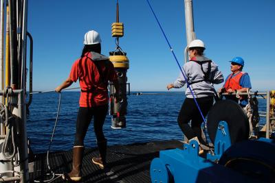
From 2007 to 2018, scientists and community partners around California conducted baseline monitoring to provide an initial snapshot of the MPAs. The monitoring involved everything from walking transects along the shore, to catching and releasing fish, to flying remotely operated vehicles thousands of feet below the surface. OPC invested $14 million in baseline monitoring, contracting with California Sea Grant to solicit, review and oversee projects.
As baseline data collection wrapped up in each region, many of the same scientists and partners began long-term monitoring with the goal of tracking how areas inside and outside of MPAs change over time. To date, OPC has invested another $15.3 million in long-term monitoring, again partnering with California Sea Grant to administer the monitoring program. Long-term monitoring helps scientists study the impacts of the MPAs and helps managers adapt to new challenges and phenomena that might arise due to climate change and other factors.
“California Sea Grant has worked closely with the Ocean Protection Council and California Department of Fish and Wildlife to administer funding for MPA research and monitoring,” California Sea Grant Director Shauna Oh said. “Our State partners looked to our program to apply the quality and credibility of Sea Grant’s independent and unbiased peer review process for the integrity of the baseline and long-term monitoring projects."
In addition to administering funding, “Sea Grant has proven invaluable in supporting the integration of monitoring results into adaptive management of MPAs,” said Esgro.
“I'm also really happy to say they've been total thought partners on a lot of this, too,” he said. “They’ve done a lot of contributing to the science surrounding MPA monitoring and evaluation and MPA management more broadly.”
The processes will likely shift over time as researchers learn more about which aspects of monitoring provide the best insights into the effects of protection on the state’s ecosystems and communities. One recent change, for example, is the inclusion of tribal communities in monitoring, which began with baseline monitoring in 2014.
The MPA Statewide Leadership Team — an advisory and decision-making body that includes partners involved in MPA management across sectors — now includes four tribal representatives. With the support of CDFW, Fish and Game Commission and Resources Legacy Fund, OPC also funded the launch of the Tribal Marine Stewards Network in 2020. Through this network, tribes across the state conduct monitoring, outreach and education in accordance with tribal priorities. The four founding tribes are the Amah Mutsun Tribal Band, the Kashia Band of Pomo Indians, the Resighini Rancheria, and the Tolowa Dee-ni’ Nation.
“Ultimately, where we want to go with that is co-management of the MPA network,” Esgro said. “And we've got a long way to go before that happens, I think, but we've also come a long way.”
To continue improving the adaptive management of the MPA network, CDFW and the Fish and Game Commission will consider the results and recommendations in the first statewide Decadal Management Review of the MPA network and Management Program, which was released in February. Many partners were integral to the effort, including California Sea Grant-funded researchers. The results are nuanced, but it’s already shaping how scientists and managers think about the network.
“Ten years is not a long time, especially in cold water ecosystems where things change slowly,” Esgro said.
Some of the MPAs were established up to five years before others, but it’s clear that areas are also changing differently depending on location. That could affect how they’re managed.
Overall, the results are encouraging. The MPAs do seem to be connected and adding to fish populations elsewhere, according to Ota.
“There are definite signs that say that these MPAs are working, and we look forward to continuing to monitor them and manage them,” she said.
As the researchers collect more data, the International Union for Conservation of Nature (IUCN) is considering listing the network on its Green List — a program that highlights best practices in international conversation.
“It’s still in the process, but if the IUCN agrees to list our MPAs, it will be the first time a network of MPAs will be on the IUCN Green List,” Ota said. The listing could help inspire other areas to create similar science-based, stakeholder designed networks. But even without it, many others around the world are already following suit.
Starr, the author of the paper that inspired the state’s approach, co-leads one of the monitoring projects: the California Collaborative Fisheries Research Program. He believes long-term monitoring will not only help scientists and managers understand whether the MPAs are working as designed, but also help researchers tease out the differences between natural and anthropogenic-caused changes. They can then use that understanding to predict and prepare for shifts within ecosystems.
“I think the next step for the MPAs besides the continued monitoring is developing expectations for what could occur and then figuring out adaptive management strategies,” Starr said.
That process will likely draw from other marine science funded by California Sea Grant around the state.
"It has been a privilege to bring federal investments to our state, enabling further research to inform the management of MPAs,” California Sea Grant Director Oh said. “And we’re committed to continuing that effort to ensure the sustainability of MPAs and improvements in the future.”
About California Sea Grant
NOAA’s California Sea Grant College Program funds marine research, education and outreach throughout California. Headquartered at Scripps Institution of Oceanography at the University of California San Diego, California Sea Grant is one of 34 Sea Grant programs in the National Oceanic and Atmospheric Administration (NOAA), U.S. Department of Commerce.


